Head Office of Geodesy and Cartography
Version 1.0.30
18th of February 2021
- References
- Terms
- Introduction
- Utilised standards
- Standardisation of local services
- Examples of implementations
- Technical solution
- Final words
- Bibliography
This guidance contains references to or derives concepts from the following documents.
INSPIRE, Implementing Directive 2007/2/EC of the European Parliament and of the Council as regards interoperability of spatial data sets and service
INSPIRE, INS NS, Commission Regulation (EC) No 976/2009 of 19 October 2009 implementing Directive 2007/2/EC of the European Parliament and of the Council as regards the Network Services
INSPIRE, INS DS, Commission Regulation (EU) No 1089/2010 of 23 November 2010 implementing Directive 2007/2/EC of the European Parliament and of the Council as regards interoperability of spatial data sets and services
OGC 09-025r2 Web Feature Service 2.0 Interface Standard – With Corrigendum
OGC 06-042 OpenGIS Web Map Service (WMS) Implementation Specification
OGC 05-078r4, OGC SLD, OGC™ Styled Layer Descriptor profile of the Web Map Service Implementation Specification, version 1.1.0 (Release 4) and its corrigendum1 for OGC Implementation Specification SLD 1.1.0 (07-123r1)
OGC 06-121r3 – OGC Web Services Common Specification (OWS) 1.1.0
Technical Guidance for the implementation of INSPIRE Discovery Services OGC 06-042 OpenGIS Web Map Service (WMS) Implementation Specification INSPIRE, INS DSTG,
Technical Guidance for the implementation of INSPIRE View Services, version 3.11, INS TG WMS+WMTS
collective service
proxy network service working on top and integrating many network services providing the same or similar spatial data sets in terms of data model but with the different spatial extent
discovery services
making it possible to search for spatial data sets and services on the basis of the content of the corresponding metadata and to display the content of the metadata [INSPIRE Directive]
download services
enabling copies of spatial data sets, or parts of such sets, to be downloaded and, where practicable, accessed directly [INSPIRE Directive]
metadata
information describing spatial data sets and spatial
network services
network services should make it possible to discover, transform, view and download spatial data and to invoke spatial data and e-commerce services [INSPIRE Directive]
spatial data
data with a direct or indirect reference to a specific location or geographic area [INSPIRE Directive]
spatial data set
identifiable collection of spatial data [INSPIRE Directive]
view service
making it possible, as a minimum, to display, navigate, zoom in/out, pan, or overlay viewable spatial data sets and to display legend information and any relevant content of metadata [INSPIRE Directive]
The responsibility for maintenance of spatial data sets differs across European Union (EU) countries. The data set belonging to the same specific INSPIRE thematic category depending on the country can be maintained on the national level, regional and local level. For example, cadastral data sets in countries like Spain or Czechia and kept on the national level, whereas in Poland the data is maintained locally.
Maintaining similar spatial data sets on a regional or local level leads to a dispersion of data sets and hinders users’ access to the spatial data. A user who wants to access and use the data published by many local or regional organisations has to put some additional effort first to find and later integrate data from many data sources. And if there are hundreds of such data sources, it may require many hours of additional work or investing extra resources on integration services provided by specialised third parties.
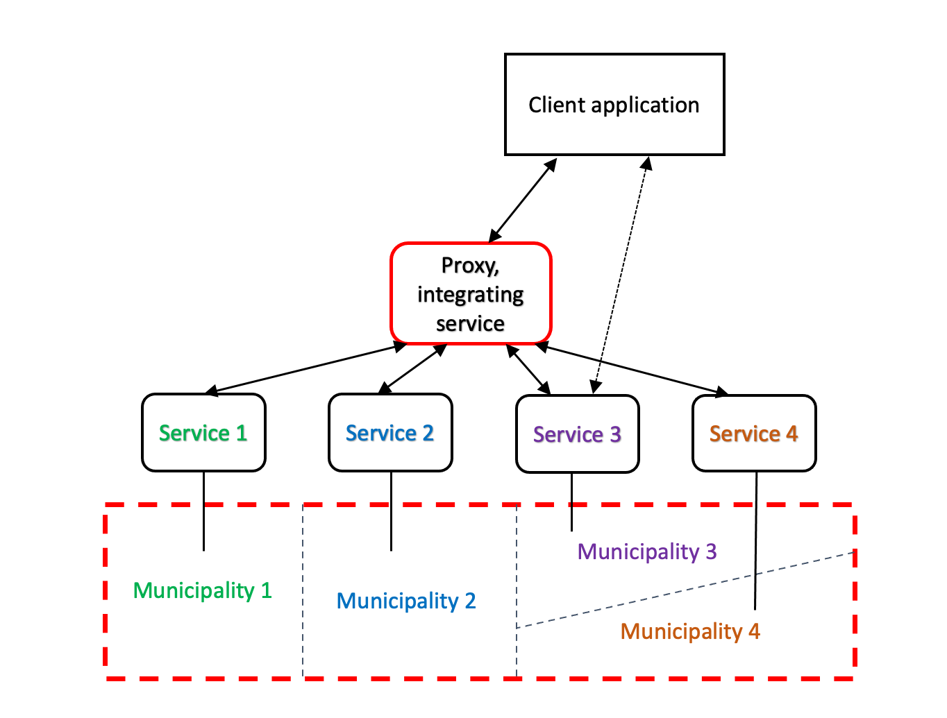
To avoid that a proxy service can be created, integrating services maintained on local levels. Such proxy service from a user perspective offers one seamless data set for the bigger area. Figure 1 shows the concept of collective service.
Figure 1 Concept of the collective service.
It is important to mention that while proxy service gives users access to data covering a bigger area, a user can still connect directly to a local service.
INSPIRE discovery services natively utilize the concept of service integration. Catalogue Service for Web (CS-W) standard supports Harvest operation that as its name suggest can harvest metadata records from local catalogue servers to a parent catalogue. Therefore, a user of parent (e.g. national) metadata catalogue has access to the metadata provided by child catalogues (e.g. regional or local). Similarly, users via EU INSPIRE metadata catalogue have access to the content of national catalogues.
However, such an approach is not natively supported in case of INSPIRE view and download services. Therefore, some additional technical solutions have to be implemented to facilitate access to local data.
This document provides guidelines on developing such collective service for view services utilising Web Map Service (WMS) standard.
It is essential to point out that professor Waldemar Izdebski is the originator and primary author of collective services for Poland.
The collective service should support WMS standards in at least two last and most popular versions 1.1.1 and 1.3.0. At the time of creating of this document, it seems that the proposed solution can also be applied for new OGC API – Maps standard that is still under development.
The guidelines contain information on setting up specific WMS services created utilising OGC WMS specifications (OGC 06-042).
Requirements and recommendations defined in INSPIRE Technical guidelines for view services (INS TG WMS+WMTS) extending OGC WMS specifications are transparent from this document perspective. Implementation of INS TG WMS+WMTS will not interfere with the features of WMS services proposed in this guidelines.
The proxy service should support at least GetCapabilities and GetMap operations. However, it is recommended that GetFeatureInfo operation is also supported.
Proxy service from a service’s user perspective works like any other WMS service. However, its backend differs from the backend of typical WMS service. The similarities and differences are explained in the following sections:
- GetCapabilities,
- GetMap,
- GetFeatureInfo.
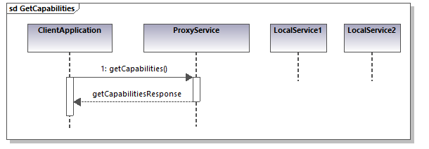
GetCapabilities operation works the same as in case of standard WMS service. The user usually via client application sends GetCapabilities request to the collective service and the service sends a typical XML response, thus the request is not forwarded to any local WMS service. This is shown in Figure 2.
Figure 2 GetCapabilities sequence diagram
The main difference between a standard WMS service and collective service is backend behaviour of GetMap operation.
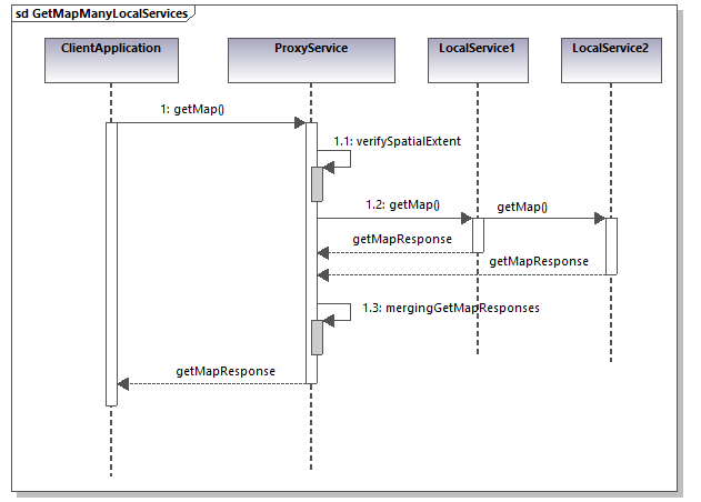
As shown in Figure 3, collective service after receiving initial GetMap request from a client application in the first step checks which local services provide data sets for the area defined in a bounding box of the request. To do this, the collective service uses the databases containing polygon geometry with spatial extents of each connected local service. Then the request is forwarded only to local services that meet selection criteria. The local services send GetMap responses with map pictures covering their respective areas. These responses are captured by collective service and merged creating one map picture. Finally, this flattened picture is returned to the client application as a GetMap response.
Figure 3 GetMap sequence diagram - basic scenario
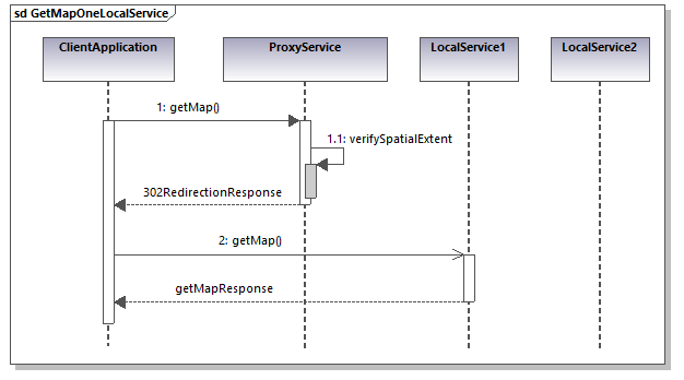
If bounding box of the GetMap request covers an area of spatial data set published by only one local service than specific optimisation can be applied. In such a scenario shown in Figure 4, the collective service does not forward the request to the local service, but it returns to the client application proper URI pointing directly to a local service. This is done utilising properties of Hypertext Transfer Protocol (HTTP). Collective service sends a response with the 302 status code. Then client application sends a new request to the local URI returned by collective service. Finally, local service sends appropriate GetMap response. If the request is correct, the response is a picture with visualisation of a data set for requested spatial extent. It is important mentioning that the whole process of redirecting the request is handled by the server and client application in the background and as such is transparent from the perspective of the end-user. Redirecting a request to a proper local service also reduces to minimum hardware resources utilised by collective service.
Figure 4 GetMap sequence diagram - one local service optimised scenario
One of the very few drawbacks of the collective services is additional time needed to process, redirect and forward the requests and responses of the services. However, if the proxy service uses appropriate hardware resources, in practice such time penalty is measured in tens of milliseconds and thus is negligible from the end-user perspective.
Handling of GetFeatureInfo requests and responses is similar to those of GetMap. The main difference is that the GetFeatureInfo responses are usually returned in HTML or XML format. GetFeatureInfo request is related to a particular pixel of a map, which is almost always covered by only one local service. As a result, responses of the local services are not merged, but the non-empty response is selected by the collective service and forwarded to a client.
To facilitate the operation of integrating collective service, the local WMS services should be standardised ideally in the following aspects:
- Coordinate Reference Systems (CRSs)
- Names of layers
- Portrayal of layers
- Structure of GetFeatureInfo responses
This can be achieved by developing a standardisation document addressing requirements in the above-mentioned areas. Additionally, the fulfilment of many standardisation requirements can be checked automatically. Therefore, to facilitate the development of local WMS services validation service can be created to validate local services against requirements defined in the standardisation document.
A local service must support at least the same CRSs as a collective service. To avoid any misunderstandings requirements regarding CRSs should be defined utilising their unique EPSG codes.
All local services connected to a proxy service should use the same names of layers. If it is beneficial to a local community, local services may publish more layers than required. However, the additional layers are visible only when a user is connected directly to a local service.
If the names of layers are not standardised the collective service when redirecting or forwarding client request to a local service can change the names of layers to those that are supported by a local service. Nonetheless, the standardisation of the layer’s names on the local service level is the recommended approach.
The local services should apply the same portrayal rules for all layers published by collective services.
If the names of layers are not standardised the collective service when redirecting or forwarding client request can apply optional SLD WMS parameter containing the reference to a file with standardised portrayal rules. However, it is recommended to standardise the portrayal rules of local services.
The local services should provide GetFeatureInfo responses with the standardised content. This allows improves the end-user experience as responses returned by different local services via collective service look the same.
For HTML format the standardisation can be achieved by developing an example of reference HTML response. In case of XML format, XSD application schema can be developed to validate GetFeatureInfo XML responses against the schema.
Again, suppose GetFeatureInfo responses of local services do not follow the standard. In that case, they can be transformed by the collective service to a common structure by applying, for example, Extensible Stylesheet Language Transformations (XSLT). Nonetheless, the standardization of the GetFeatureInfo responses on a local service level is the recommended approach.
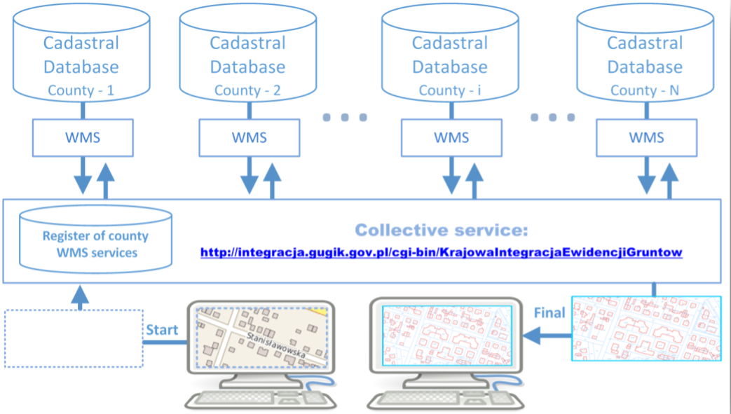
Collective services have been developed in Poland. The services integrate data sets maintained at a local level by 380 counties (powiaty). There are following collective services available:
- KIEG – providing cadastral data (cadastral parcels and buildings) https://integracja.gugik.gov.pl/cgi-bin/KrajowaIntegracjaEwidencjiGruntow
- KIUT - providing data about utilities networks (electricity, water, telecommunication, sewers, gas and other) https://integracja.gugik.gov.pl/cgi-bin/KrajowaIntegracjaUzbrojeniaTerenu
- KIBDOT – providing large scale topographic data (containing the location of fences, trees, curbs, etc. ) https://integracja.gugik.gov.pl/cgi-bin/KrajowaIntegracjaBazDanychObiektowTopograficznych
Figure 5 Collective service scheme for cadastral data in Poland (KIEG)
The collective services have been created utilising mainly Open Source software with additional custom scripts.
To homogenise portrayal and content of collective network service standardisation documents have been created and endorsed by GUGiK and all major companies developing the software that helps local governments in Poland maintain the spatial data. The standards are available for KIEG and KIUT. Additionally, a web application is available for validating KIEG and KIUT services published by counties against above-mentioned standards.
The backbone of the Polish solution is MapServer. MapServer is an Open Source software that can act as a WMS Server as well as a WMS Client. The MapServer allows for use of data from different servers, and enables the creation of a network of WMS services from which clients can build customized maps. Detailed documentation containing information about using MapServer’s WMS connection type to include layers from remote WMS servers can be found on MapServer website.
Guidelines of setting up a simple integration service can be found in the Description of a testbed implementation of collective WMS service document.
This document focuses on the development of collective services with WMS interface. A similar approach can be utilized to develop a download Web Feature Service (WFS) or Web Coverage Service (WCS). However, due to the much higher complexity and heterogeneity of WFS and WCS service responses, such implementation would require much additional effort to standardize and automatically integrate local services responses.
Izdebski, W. (2017, 22 September). Analysis of the cadastral data published in the Polish Spatial Data Infrastructure. Polish Academy of Sciences. Retrieved from http://www.izdebski.edu.pl/kategorie/Publikacje/2017_WaldemarIzdebski_Analysis_of_the_cadastral_data_published_in_the_Polish_SDI.pdf
Izdebski, W. (2017). Analysis of possibilities to increase the accessibility of WMS services from cadastral databases. Roczniki Geomatyki 2017, tom XV, zeszyt 4(79). Retrieved from http://www.izdebski.edu.pl/kategorie/Publikacje/pobierz.php?p=2017_PTIP_Izdebski_AnalizaMozliwosciZwiekszeniaDostepnosciDanychEwidencyjnychIIP.pdf
